
A campaign led by Togo to persuade the United Nations General Assembly to move away from the centuries-old Mercator world map has reignited debate over how maps shape global perceptions of Africa.
The proposal, expected to be presented before the UN in September, was endorsed by the African Union in April after heads of state raised the issue during the bloc’s February summit. African leaders backed a push to replace the long-dominant Mercator projection with an alternative that more accurately reflects the true size of the world’s continents, particularly Africa.
For campaigners, the issue goes far beyond cartography. They argue that the maps commonly displayed in classrooms, offices and institutions subtly reinforce global power imbalances inherited from the colonial era.
“Maps are not neutral,” said Faya Ndiaye, co-founder and deputy executive director of the advocacy organisation Speak Up Africa. “The way the world is represented influences how people think about power, importance and relevance.”
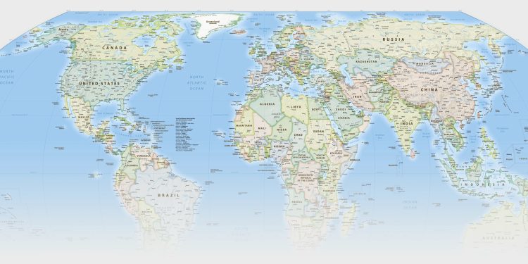
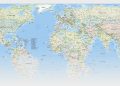
The Mercator projection, still one of the most widely used maps in the world, dramatically enlarges countries in the northern hemisphere while shrinking those closer to the equator. Greenland, for example, appears almost as large as Africa despite Africa being roughly 14 times bigger in reality.
For Ndiaye, those distortions matter.
“When Africa is constantly represented as smaller than it actually is, it sends a message — consciously or unconsciously — that the continent is less significant,” she said. “That can affect how Africa is perceived in global conversations, including political and economic negotiations.”
The African Union echoed those concerns in a statement supporting the adoption of the Equal Earth projection, a newer map designed to preserve the relative size of land masses without heavily distorting their shapes.
“The Mercator cartographic projection distorts the real size of the African continent, influences perceptions, and negatively affects the objective assessment of Africa’s economic viability,” the AU said.
The irony was not lost on critics that the Mercator outline still appears in the AU’s own logo.
The debate over maps forms part of a broader effort to challenge narratives about Africa that many scholars and activists say remain rooted in colonial assumptions.
Carlos Lopes, an associate professor at the Mandela School of Public Governance at the University of Cape Town and one of the academics behind the Correct the Map initiative, said geography remained one of several enduring symbols shaping how the continent is viewed internationally.
“There are markers that continue to influence perceptions of Africa,” Lopes said. “One of those markers is the way we look at geography.”
The Correct the Map project, launched in 2025 with the narrative-change organisation Africa No Filter, seeks to encourage institutions, schools and media outlets to adopt projections that represent continents more accurately.
The campaign comes amid renewed scrutiny of the Mercator projection, first created in 1569 by the Flemish geographer Gerardus Mercator.
At the time, the map represented a scientific breakthrough. Mercator devised a projection that enabled sailors to navigate more easily across oceans because compass directions could be plotted as straight lines. For maritime navigation during the age of exploration, the map proved revolutionary.
But critics argue that its continued dominance reflects a worldview shaped by European imperial expansion.
“Maybe Mercator did not intend to minimise Africa,” Ndiaye said. “But we know that it was important for European powers to place Europe at the centre of the world.”
Lopes agrees that the projection must be understood within its historical context.
“In the 16th century, the Mercator map was amazingly progressive,” he said. “It was an ambitious attempt to bring the world together through a unified representation. But that was the 16th century — not today.”
He added: “Continuing to privilege that worldview can only be justified by habit and by the power dynamics of that period. We now know better.”
The controversy over world maps is not new. During the independence movements that swept across Africa in the 1950s and 1960s, newly independent states sought to erase colonial symbols by renaming streets, cities and even countries.
When the British colony known as the Gold Coast gained independence in 1957, it adopted the name Ghana in honour of the ancient Ghana empire. Following independence from Britain in 1980, Rhodesia became Zimbabwe, while its capital, Salisbury, was renamed Harare.
Yet debates over how Africa itself was represented on maps remained largely confined to academic circles until the emergence of the Gall-Peters projection.
The map was first outlined in 1855 by the Scottish clergyman and cartographer James Gall. More than a century later, the German historian Arno Peters revived the concept and propelled it into international debate during the 1970s.
Peters argued that most conventional maps reflected colonial bias because they exaggerated the size of Europe and North America while diminishing the global south. His projection sought to preserve the correct relative area of continents, making Africa and South America appear far larger than on the Mercator map.
He branded it the “Peters World Map” and promoted it as a fairer and more socially just representation of the world.
“The Peters projection became quite influential within the UN system,” Lopes said. “A number of UN agencies started producing maps using it.”
By the mid-1970s and 1980s, organisations including Unesco, Unicef and the World Council of Churches had adopted the projection. It also became widely used in schools in parts of the UK and the US.
But while the Gall-Peters map corrected distortions in land area, it created new distortions in shape. Countries near the equator, such as the Democratic Republic of Congo and Indonesia, appeared stretched vertically, while countries farther north, including Canada and Russia, looked flattened and unnaturally broad.
The backlash was swift. In 1989, several US geographic organisations, including the National Geographic Society and the American Cartographic Association, called for a ban on all rectangular world maps, including the Peters projection, arguing that no flat map could perfectly represent the globe.
Today’s push by Togo and the African Union seeks to move the conversation beyond technical debates among cartographers and into the public sphere.
Campaigners argue that changing maps alone will not alter entrenched inequalities, but say representation still matters because visual images influence the assumptions people carry about the world.
For Ndiaye, the issue is ultimately about ownership.
“This is about Africans taking full ownership over how our continent is represented globally,” she said. “Maps shape imagination. They shape understanding. And they shape the way power is perceived.”


Discussion about this post